


Just south of the tiny town of Rochford, Castle Peak stands deep in the Black Hills and can be extremely difficult to find. There are no obvious signs acknowledging the mountain and it isn't noted on many maps. Its actual height is disputed (it is somewhere between 6,337 ft and 6,358 ft tall). Remote and obscure, this peak was our finish line for a wild and beautiful hike through South Dakota woodlands.


The dirt roads that create a maze around Castle Peak aren't well marked and can be difficult to navigate. We strongly recommend the use of a map (we did and it was still confusing). Some roads were missing their markers and others had signs that were hard to see or easy to miss.

From the town of Rochford we headed southeast on South Rochford Road. After several miles we took a left onto USFS Road 238, which is easy to overlook. USFS 238 has a small road marker and looks as if it heads into a residential area. In fact, the first few miles of this road pass through an area known as Myersville. Once a gold rush town, its population has shrunk from 200 at its peak to the approximate 10 citizens that still live in this modern ghost town. Once on the other side of Myersville, the road returns to National Forest property.


Once past Myersville, the road gets rockier and harder to traverse as it goes along. We slowly navigated the road as it crept uphill, but it eventually became too rough for us to continue driving. We reached a spot that provided enough room to pull safely off the road. From where we had parked it would be about a 2 mile hike to the summit.


We hiked the rough dirt road as it led us farther into the forest. After a while we reached a fork in the road. A left would keep us on USFS 238 but a right led to what we were looking for -a 3-way fork in the road. USFS 238.1F was on the left and USFS 238.1E was on the right, but we wanted the center road. This was USFS 238.1A, which at the time was missing its marker. 238.1A leads directly to (and ends at) the top of Castle Peak.


From the 3-way fork it was about 1 mile to the summit. The last part of the hike was a fairly steep climb. We stopped several times on the way up for brief rests and water breaks. As we ascended through the dense forest, views of distant hills began to appear through the trees. It was slow going along this rocky road as it stretched up the mountain.


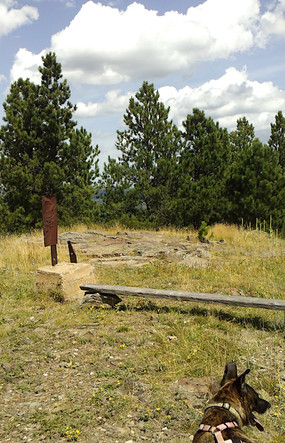
Eventually we reached the top. We found a pile of old timbers and a natural set of stone steps upon our arrival. The summit itself was a large stone cap surrounded by a small clearing, which provided unobstructed views in most directions.


The cement bases and remnants of an old fire tower were scattered around the mountaintop. Aged pieces of wood littered the area as a reminder of the structures that formerly sat here. An open cement pit that had once served as a latrine could be found just below the summit. A makeshift bench had been made out of some of the old boards.


Some of the views around us were obstructed by trees, but for the most part the vistas were nice. We could see distant wooded hills and were able to spot Flag Mountain, Reynolds Prairie, and Terry Peak in addition to other mountains and landmarks.


We sat in the shade under a group of trees, enjoying the mountaintop. We relaxed and had some water and treats. Then the dogs had fun sniffing around and taking in the views from atop the hill. We lingered until everyone was rested and ready to go. Then we took one last look at the scenery before heading back down the mountain.


We could see a storm gathering off in the distance, which wasn't much concern as it seemed to be headed away from us. As we hiked back down, the hilltops slowly disappeared below the trees. The girls and I had to step carefully over the uneven terrain as we made our descent.

The trek down was much faster than the ascent. We took fewer breaks on the way down, which enabled us to move fairly quickly. The girls occasionally stopped and perked up at the sight of a chipmunk or the sound of rustling in the nearby bushes. Lower along the trail, wildflowers were in bloom. This was a beautiful section of South Dakota forest and a lovely way to spend an afternoon.


From start to finish our hike lasted about 3 hours (including breaks and time to enjoy the top of the mountain). The girls seemed to have a fun time on our adventure and got in a good amount of exercise in the process. It was challenging and a bit strenuous. We strongly recommend bringing along lots of water -we went through a good amount during our trek.
This wild climb through dense forest was quite an experience. After navigating the tricky woodland roads and completing the steep hike, it certainly felt like Castle Peak's vistas had been well-earned.


ความคิดเห็น